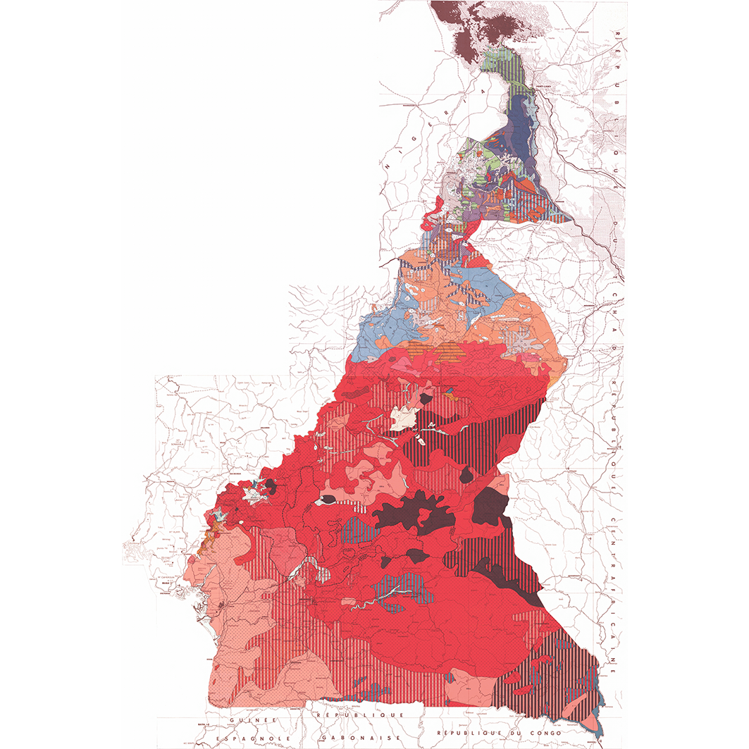
Carte pédologique du Cameroun oriental. One mosaic of 2 map sheets. Scale of 1:1 000 000. Date of publication: 1965.
One mosaic of 2 map sheets:
1. Carte pédologique du Cameroun oriental : feuille Nord. Scale of 1:1 000 000. Date of publication: 1965.
2. Carte pédologique du Cameroun oriental : feuille Sud. Scale of 1:1 000 000. Date of publication: 1965.
Simple
- Date (Publication)
- 1965-01-01
- Citation identifier
- IRD_CMR_PEDO_1965_1000000
- Credit
-
The region Île-de-France, under the project NumeriSud, supported the action to transforme around 2800 maps that are conserved at the Institut de recherche pour le développement (IRD) library in Bondy into a standard coordinate system. The transformation of the images has been done by:
GMR (Global Mapping Resources)
P.O. Box 414113
Craighall 2024
South Africa
email: Maurizio@madmappers.com
www: http://www.madmappers.com
GRM has extensive international experience in this kind of work.
- Status
- Completed
- Point of contact
-
Organisation name Individual name Electronic mail address Role Institut de recherche pour le développement (IRD)
IRD cartothèque
Point of contact Institut de recherche pour le développement (IRD)
IRD NumeriSud
Point of contact Institut de recherche pour le développement (IRD)
Zaiss, Rainer
Author
- Maintenance and update frequency
- Not planned
-
GEMET - INSPIRE themes, version 1.0 INSPIRE themes
-
-
Soil
-
-
GEMET - Concepts, version 2.4
-
-
soil map
-
-
Geounits
-
-
Africa
-
Middle Africa
-
Cameroon
-
- Theme
-
-
thematic map
-
- Keywords
-
-
project NumeriSud
-
national coverage
-
local coverage
-
- Use limitation
-
If you reuse this data you must cite this dataset as follows:
IRD (éditeur) (2014): Carte pédologique du Cameroun oriental. One mosaic of 2 map sheets. Scale of 1:1 000 000. Date of publication: 1965. Project NumeriSud SPHAERA-GEO. Bondy, France.
Additionally, you must acknowledge the following resource:
Zaiss, R. (éditeur) (2014): Project NumeriSud SPHAERA-GEO, Géoréférencement et mosaïquage des cartes de l’IRD. Bondy, France.
- Access constraints
- licence
- Classification
- Unclassified
- Spatial representation type
- Grid
- Denominator
- 1000000
- Language
-
fre
- Character set
- UTF8
- Topic category
-
- Geoscientific information
))
- Begin date
- 1965-01-01
- End date
- 1965-12-31
- Supplemental Information
-
Publication(s):
Martin, D., Ségalen, P. (1965): Carte pédologique du Cameroun oriental au 1/1 000 000. Paris (FRA) : ORSTOM, Office de la recherche scientifique et technique outre mer, Service cartographique.
Martin, D., Ségalen, P. (1965): Carte pédologique du Cameroun oriental au 1/1 000 000. Yaoundé (CMR) : ORSTOM, Office de la recherche scientifique et technique outre mer.
- Reference system identifier
- EPSG / WGS 84 (EPSG:4326) / 7.9
- Distribution format
-
Name Version ECW
GlobalMapper 10
- Hierarchy level
- Dataset
- Statement
-
1. Scanning to tif format, 256 colors, 250dpi.
2. Georeferencing and if possible reprojection to WGS84 (Longitude / Latitude).
3. Clipping and mosaicing of map sheets(s).
4. Export ECW format.
Metadata
- File identifier
- 09b42b1c-4bdd-4bf8-a212-30490f1c2679 XML
- Metadata language
-
eng
- Character set
- UTF8
- Hierarchy level
- Dataset
- Hierarchy level name
-
dataset
- Date stamp
- 2016-01-01T12:04:21
- Metadata standard name
-
ISO 19115:2003/19139
- Metadata standard version
-
1.0
- Metadata author
-
Organisation name Individual name Electronic mail address Role Institut de recherche pour le développement (IRD)
IRD cartothèque
Point of contact Institut de recherche pour le développement (IRD)
IRD NumeriSud
Resource provider Institut de recherche pour le développement (IRD)
Zaiss, Rainer
Resource provider
Overviews
Spatial extent
Provided by
