Campagne océanographique - LANGOLF (LANgoustine GOLFe de Gascogne)
Calcul de l'indice d'abondance du stock de langoustines dans la Grande Vasière (golfe de Gascogne), structure des tailles et des sexes ; distribution spatiale de la population par unité sédimentaire. Observation macroscopique des stades de maturité sexuelle chez les femelles. Estimations de l'indice d'abondance pour les espèces apparentées. Des parties calcifiées ont été prélevées pour déterminer l'âge des espèces d'intérêt commercial dont la dynamique des stocks est suivie. Stades de maturité sexuelle chez la sole, la baudroie et le merlu. Relevés de température, de salinité et de profondeur effectués (Campagnes FIS).
Simple
- Date (Publication)
- 2006-04-07
- Citation identifier
- FR-DCSMM-PDS-LANGOLF
- Presentation form
- Digital profile
- Purpose
-
Les objectifs de la campagne sont :
(i) L’estimation d'un indice d'abondance du stock de langoustines, structure en taille par sexe.
(ii) La distribution spatiale par unité sédimentaire de la population
(iii) L’ observation macroscopique des stades de maturité sexuelle des femelles.
(iv) L’estimation des indices d'abondances des espèces associées aux captures expérimentales
(v) (notamment merlu, galathée, baudroies commune et rousse, tacauds, merlan bleu, sole perdrix).
(vi) Les prélèvement de pièces calcifiées pour la détermination de l'âge des poissons (espèces à intérêt commercial dont la dynamique est suivie).
(vii) L’échantillonnage par strate sédimentaire de la macro-faune et méga-faune benthique associée
- Credit
-
IFREMER
- Status
- On going
- Point of contact
-
Organisation name Individual name Electronic mail address Role IFREMER
IFREMER SIH
Author IFREMER
IFREMER SIH
Publisher
- Maintenance and update frequency
- historical
- Theme
-
-
Espèces
-
Assemblage
-
Benthos
-
Strates sédimentaires
-
Langoustine, merlu
-
Taille, sexe
-
Echantillonnage stratifié
-
-
GEMET - INSPIRE themes, version 1.0
-
-
Installations de suivi environnemental
-
-
Sous-regions marines
-
-
/Métropole/Golfe de Gascogne
-
-
DCSMM : Type d'espace concerné
-
-
Pas d'espace particulier concerné
-
-
DCSMM : Descripteurs
-
-
D3: Espèces commerciales
-
-
DCSMM : Méthodes de recueil des données
-
-
Observation directe
-
-
Thèmes Sextant
-
-
/Activités humaines/Campagnes océanographiques
-
-
SIH - Types de jeu de données
-
-
/Données observées/Campagnes
-
-
SIH - Façade maritime
-
-
Atlantique
-
-
Cadre Réglementaire - SIMM
-
-
Directive Cadre Stratégie pour le Milieu Marin (DCSMM)
-
-
Thématiques - SIMM
-
-
/Activités et Usages/Pêche et Aquaculture
-
- Access constraints
- Restricted
- Association Type
- Cross reference
- Initiative Type
- Platform
- Language
- Français
- Character set
- UTF8
- Topic category
-
- Oceans
- Begin date
- 2006-04-07
- End date
- 2013-05-21
))
- Supplemental Information
-
Financeurs :
IFREMER
Europe
Direction Générale des Affaires Maritimes, de la Pêche et de l'Aquaculture (DGAMPA)
- Distribution format
-
Name Version
- OnLine resource
-
Protocol Linkage Name OGC:WMS
https://sextant.ifremer.fr/services/wms/sismer campagnes_LANGOLF
WWW:LINK
https://sih.ifremer.fr/prive/Acces-aux-donnees/Extractions/Campagnes/Donnees-Campagnes-halieutiques Accès aux données des campagnes halieutiques du SIH
- Hierarchy level
- Dataset
Absolute external positional accuracy
Conformance result
- Date (Creation)
- 2012-01-16
- Explanation
-
Non évalué
- Pass
- No
- Statement
-
Sur l'ensemble du secteur, d'une superficie totale de 11680 km² environ, cinq strates sédimentaires en fonction de la teneur en vase et de son origine ont été définies.. Ce plan d’échantillonnage est aléatoire stratifié avec une allocation proportionnelle à un ratio prenant en compte : (1) la surface de chaque strate et (2) un indice relatif à la concentration des navires de pêche.
Les stations sont tirées selon un processus aléatoire
L'engin de pêche est constitué de chaluts jumeaux (deux chaluts reliés par leurs pointes d'ailes au centre) tels que ceux employés par les
professionnels à la différence près du maillage du cul ramené à 20 mm étiré afin de permettre la rétention de jeunes individus.
Chaque chalut est muni d'un équipement SCANMAR 'corde de dos' et 'pointes d'ailes' pour la vérification de la géométrie du train de
pêche pendant les traits (ouvertures verticales et horizontales), et la définition du moment de début du trait sur le fond. Les panneaux sont équipés du dispositif GEONET permettant d'obtenir des données sur la géométrie de l'engin et sur la température au fond. Grâce à ces dispositifs, il est possible de calculer la surface effectivement balayée sur le fond par unité d'échantillonnage.
Une sonde est fixée sur la corde de dos du chalut pour l’acquisition des paramètres hydrologiques (Pression, température et conductivité).
Le plan d'échantillonnage standard prévoit 70 stations de chalutage d'une durée de 30 minutes.
A chaque trait différents relevés sont effectués :
1) performances des chaluts
2) observation biologiques sur l’ensemble des espèces
3) mesures hydrologiques et bathymétriques
• Plan(s) d’échantillonnage :
Aléatoire, stratifié
• Précision sur le type de donnée :
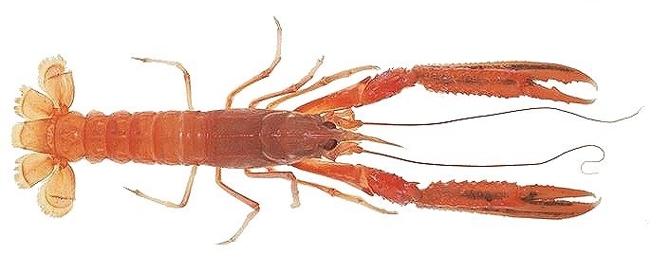
Lepidorhombus whiffiagonis, Lophius budegassa, Lophius piscatorius,Merluccius merluccius, Solea vulgaris, mullus surmulutus, Nephrops norvegicus
• Paramètre(s) observé(s) ou mesuré(s) :
Taille
Sexe
Maturité
Prélèvement des otolithes
Identification
Assemblage
Abondance
• Résolution du (ou des) paramètre(s) :
Par opération de pêche, analyse systématique des captures de pêche scientifiques
• Format(s) :
Les données disponibles existent sous le format : csv
- Description
-
Type de données :
Les Actinoptérygiens
crustacés
benthos
Précision sur le type de donnée :
Lepidorhombus whiffiagonis, Lophius budegassa, Lophius piscatorius,Merluccius merluccius, Solea vulgaris, mullus surmulutus, Nephrops norvegicus
Paramètre(s) observé(s) ou mesuré(s) :
Taille
Sexe
Maturité
Prélèvement des otolithes
Identification
Assemblage
Abondance
Fréquence d'actualisation :
annuelles
Fréquence d'observation :
14 jours tous les ans
Metadata
- File identifier
- b531674a-b4f1-4730-ab54-4e0f9c4be641 XML
- Metadata language
- Français
- Character set
- UTF8
- Parent identifier
-
Campagnes océanographiques - Observations pour la surveillance halieutique
99e16a35-8090-4897-aa2b-c5c0951aabea
- Hierarchy level
- Series
- Date stamp
- 2025-05-15T23:50:25.503202Z
- Metadata standard name
-
ISO 19115-3 - SEXTANT ISO 19115-3 - SEXTANT
- Metadata standard version
-
1.0
- Metadata author
-
Organisation name Individual name Electronic mail address Role IFREMER SIH
Point of contact
Overviews
Spatial extent
Provided by
