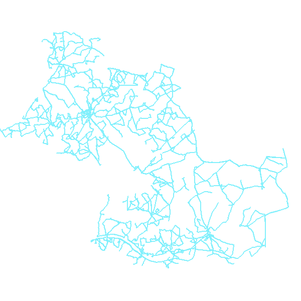
Itinéraires de transport scolaire gérés par le Conseil général de Loir-et-Cher
Tracé à moyenne échelle des itinéraires empruntés par les transports assurant la desserte des établissements scolaires sous la responsabilité du Conseil général. Ces tracés excluent de fait la desserte des communes de la Communauté d'agglomération Agglopolys.
La couche ne contient pas les itinéraires de retour dont le tracé serait différent du tracé aller, ni les itinéraires "simplifiés" utilisés en cas d'intempéries hivernales.
Simple
- Date (Revision)
- 2013-05-23T15:30:00
- Date (Revision)
- 2013-05-15T15:11:00
- Citation identifier
- https://catalogue.doterr.fr/geonetwork/srv/c88335fe-4183-4b1a-a3fd-675057a146bf
- Point of contact
-
Organisation name Individual name Electronic mail address Role Conseil général de Loir-et-Cher
Frédéric FOUGERAY
Author
- Keywords
-
-
GEMET - INSPIRE themes, version 1.0
-
-
Réseaux de transport
-
- Keyword
-
Transport collectif
- Keyword
-
Conseil général 41
- Keyword
-
Service de transport
- Type
- Theme
- Date (Publication)
- 2023-07-12
- Use limitation
-
Aucune condition ne s’applique
- Access constraints
- Other restrictions
- Use constraints
- Intellectual property rights
- Other constraints
-
Etalab
- Classification
- Unclassified
- Spatial representation type
- Vector
- Denominator
- 50000
- Language
-
fre
- Character set
- UTF8
- Topic category
-
- Transportation
- Description
-
LOIR-ET-CHER
))
- Description
-
LOIR-ET-CHER
- Reference system identifier
- EPSG:27582
- Reference system identifier
- EPSG:4326
- Reference system identifier
- EPSG:2154
- Reference system identifier
- EPSG:27572
- Reference system identifier
- EPSG:27562
- Reference system identifier
- EPSG:4258
- Reference system identifier
- EPSG:32620
- Reference system identifier
- EPSG:3943
- Reference system identifier
- EPSG:3947
- Reference system identifier
- EPSG:3948
- OnLine resource
-
Protocol Linkage Name OGC:WMS-1.1.1-http-get-map
https://carto.doterr.fr/cgi-bin/mapserv? CG41ItiTransportScolaire
OGC:WFS-1.0.0-http-get-capabilities
https://carto.doterr.fr/cgi-bin/mapservwfs? CG41ItiTransportScolaire
WWW:DOWNLOAD-1.0-http--download
https://catalogue.doterr.fr/geosource/panierDownloadFrontalParametrage?LAYERIDTS=3714 Accès au téléchargement des données
WWW:LINK-1.0-http--link
https://catalogue.doterr.fr/geosource/consultationWMS?IDT=3714 Accès à la visualisation des données
- Hierarchy level
- Dataset
- Statement
-
Le support utilisé pour la numérisation des tracés est le SCAN25
Metadata
- File identifier
- c88335fe-4183-4b1a-a3fd-675057a146bf XML
- Metadata language
-
fre
- Character set
- UTF8
- Hierarchy level
- Dataset
- Date stamp
- 2015-04-08T15:21:05
- Metadata standard name
-
ISO 19115:2003/19139
- Metadata standard version
-
1.0
- Metadata author
-
Organisation name Individual name Electronic mail address Role Observatoire de l'économie et des territoires de Loir-et-Cher
Christophe LEFERT
Originator
Overviews

Spatial extent
Provided by
